
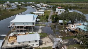
 When Hurricane Idalia roared towards Florida’s Big Bend in August 2023, it stunned forecasters with its sudden burst of power. In less than 24 hours, the storm grew rapidly from a Category 1 to a powerful Category 4 hurricane, a process called rapid intensification that made predicting its final strength extremely difficult.
But what gave Idalia this extra boost? A new study by scientists from the University of South Florida (USF) College of Marine Science suggests the answer may have been flowing in quietly from the land river water.
For decades, forecasters have known that warm ocean waters, atmospheric heat, and wind conditions help fuel storms. But these usual suspects couldn’t fully explain Idalia’s explosive growth, especially since the storm’s wind conditions weren’t particularly favorable for such rapid strengthening during its final phase.
That left scientists with a mystery: what else was feeding this monster storm?
The Hidden Role of Freshwater Plumes
The researchers turned their attention to something many hurricane models overlook a vast plume of fresh river water that stretched from the Mississippi River down the Gulf Coast to the Florida Keys. This low-salinity water, dumped into the Gulf from rivers along the coast, floated on top of the saltier ocean water, forming a thick, stubborn surface layer.
This mattered because when strong winds blow over the ocean, they usually stir up the water, bringing cooler, deeper water to the surface. This cooling process removes some of the heat energy that storms depend on to grow stronger. But during Hurricane Idalia, that layer of freshwater acted like a lid, blocking this natural mixing process. As a result, the warm surface water stayed warm providing the perfect fuel for the storm to rapidly intensify.
“Normally, winds mix shallow warm water with deeper cool water,” explained Chuanmin Hu, professor of oceanography at USF and co-author of the study. “But this time, the fresh river water on top made that mixing much harder. It let the surface stay warm just what the hurricane needed to grow fast.”
A NASA Earth Observatory map confirms this freshwater plume stretched right along Idalia’s path, from Mississippi to the Florida Keys.
A Surprising Discovery
Interestingly, the research team hadn’t set out to study hurricanes at all. They were originally tracking phytoplankton and dissolved matter in river plumes using satellite data and underwater gliders. But when Hurricane Idalia spun through the region, they realized their data could reveal much more and help solve the puzzle of the storm’s surprise intensification.
Their discovery backs up past studies that also highlighted river plumes as storm intensifiers. A 2007 paper, for example, showed that many of the world’s strongest storms including over two-thirds of Category 5 hurricanes from 1960 to 2000 — passed over giant freshwater plumes from the Amazon and Orinoco rivers in South America.
A Call for Better Forecasting
For Hu and his colleagues, the message is clear: forecasters need to pay attention to river plumes if they want to predict dangerous storms more accurately.
“Storm forecasts are life-saving tools that help people prepare and evacuate in time,” Hu said. “If these river plumes are in the right place at the right time, they can make hurricanes much stronger than expected. That’s why they need to be part of the models we use to predict storms.”
The study, published in Environmental Research Letters, suggests that including river plume data in forecasting systems could make predictions of storm strength especially rapid intensification far more reliable.
As hurricanes become more intense in a warming world, understanding all the hidden factors that fuel them could help coastal communities better prepare for what lies ahead.