Thursday, October 9News That Matters

Tag: earthquake

Magnitude 6.8 Earthquake Strikes Eastern Mindanao, Triggered by Previous Major Seismic Event

Magnitude 6.8 Earthquake Strikes Eastern Mindanao, Triggered by Previous Major Seismic Event

Breaking News, Disasters
A magnitude 6.8 earthquake struck offshore eastern Mindanao in the southern Philippines, resulting from renewed movement along a subducting fracture zone. The tremor, which occurred at 6:23 a.m. local time, was centered 48 kilometers east-northeast of Lingig, Surigao del Sur, at a depth of 25 kilometers. This event follows a magnitude 7.4 earthquake that hit the region eight months earlier, indicating a possible connection between the two seismic occurrences. The Philippine Institute of Volcanology and Seismology (PHIVOLCS) reported that the earthquake did not cause significant damage or casualties, although it was followed by six aftershocks ranging in magnitude from 4.8 to 6.2. These aftershocks occurred at shallower depths, further unsettling the region. Seismotectonic Background ...
Nankai Subduction Zone’s Magnitude 7.1 Earthquake: Potential Implications and Advisory Measures

Nankai Subduction Zone’s Magnitude 7.1 Earthquake: Potential Implications and Advisory Measures

Breaking News, Disasters
On August 8, 2024, a magnitude 7.1 earthquake struck approximately five to ten kilometers off the shores of Miyazaki, a city on Japan's southern island, Kyushu. The earthquake, which occurred at a depth of 25 kilometers, is believed to have originated from the Nankai Trough subduction zone interface. Although the region is no stranger to seismic activity, the recent event has raised concerns about the possibility of a larger megathrust earthquake. Context and Historical Seismic Activity The Nankai subduction zone is notorious for producing massive earthquakes, with magnitudes ranging from 8 to 9, occurring approximately every 100 to 200 years. However, the recent magnitude 7.1 shock occurred in a zone characterized by repeating magnitude ~7 earthquakes every 25 to 30 years, typically...
Strong 6.5 Earthquake Hits Near Antofagasta Chile

Strong 6.5 Earthquake Hits Near Antofagasta Chile

Breaking News, Disasters
Antofagasta, Chile – A strong earthquake with a magnitude of 6.5 struck 265 kilometers east of the coastal city of Antofagasta, Chile, at a depth of 128 kilometers, according to the US Geological Survey (USGS). The tremor occurred at 9:51 PM local time, and there were no immediate reports of damage. Agence France-Presse (AFP) reported that no tsunami warning has been issued following the earthquake. In January, a magnitude 5.3 earthquake struck the northern Chilean region of Tarapaca at a depth of 118 kilometers, with no loss reported at the time. Chile's Earthquake Prone History Chile, located on the Pacific Ocean’s “Ring of Fire,” is one of the world’s most earthquake-prone countries. This seismically active region is notorious for frequent volcanic eruptions and earthquakes....
Major Earthquake 2,500 Years Ago Likely Altered Ganges River Course, Study Finds

Major Earthquake 2,500 Years Ago Likely Altered Ganges River Course, Study Finds

Breaking News, Disasters, Learning & Developments
A major earthquake more than 2,500 years ago likely caused one of the world's largest rivers to change its course, according to a study published today in the journal Nature Communications. The findings by a global research team suggest that a similar event could have the potential to alter the river's course again in the future. The modern Ganges River, spanning 2,500 kilometers, flows from the Himalayas southeastward into Bangladesh, where it is known as the Padma River. It then connects with the Brahmaputra and Meghna rivers. Currently, the Ganges-Padma is located around 50 kilometers south of Dhaka. However, satellite imagery has revealed evidence of its former course, approximately 100 kilometers from the city. This discovery indicates that a major event, likely seismic activity...
Scientists Warn Cascadia Faultline Could Trigger Catastrophic Earthquake and Tsunami on West Coast

Scientists Warn Cascadia Faultline Could Trigger Catastrophic Earthquake and Tsunami on West Coast

Breaking News, Disasters
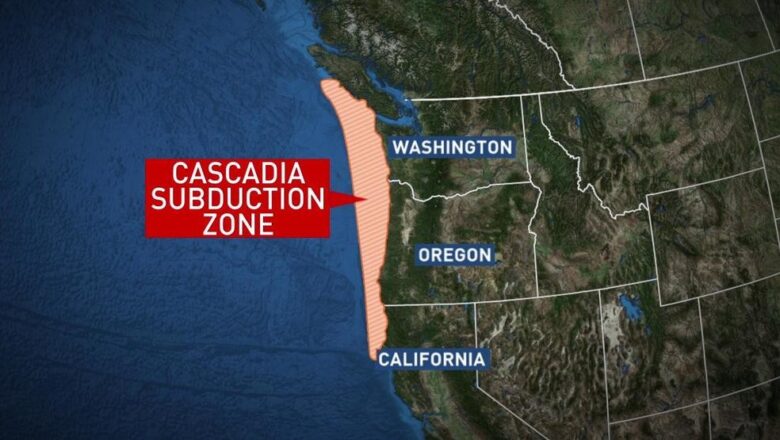
Scientists have raised alarms about the Cascadia Subduction Zone, an underwater faultline off the west coast of America, that could unleash a devastating earthquake and tsunami at any moment. This faultline spans 600 miles (966 kilometers) from Southern Canada to Northern California. Recent underwater mapping has revealed that this faultline, typically divided into two parts, is now splitting into four sections, indicating heightened risk. The Cascadia Subduction Zone has been identified as a major geological threat due to its immense potential for seismic activity. If there is even slight movement in the tectonic plates here, it could trigger catastrophic destruction. Scientists warn that this faultline could generate an earthquake with a magnitude exceeding 9.0, far surpassing the cap...
New Research Highlights Earthquake Threat in the Cascadia Subduction Zone

New Research Highlights Earthquake Threat in the Cascadia Subduction Zone

Breaking News, Disasters
The Cascadia Subduction Zone (CSZ), a major geological faultline stretching 1,000 kilometers from Northern California to British Columbia, Canada, is under renewed scientific scrutiny. This zone, marking the boundary between the Juan de Fuca and North American tectonic plates, is not only a key interest for geologists but also a potential source of one of the most powerful earthquakes and tsunamis the world could experience. A new study published in Science Advances on June 7, has brought this peril into sharper focus, indicating that regions within the CSZ might rupture individually or simultaneously, leading to varying impacts. The study underscores the significant threat posed by the CSZ, where massive earthquakes have the potential to generate tsunamis over 100 feet high. Harold Tob...
Magnitude 6.3 Earthquake Strikes Vanuatu: No Tsunami warning issued by agency

Magnitude 6.3 Earthquake Strikes Vanuatu: No Tsunami warning issued by agency

Breaking News, Disasters
A magnitude 6.3 earthquake hit the Pacific nation of Vanuatu on Sunday morning, according to the United States Geological Survey (USGS). The tremor occurred at 9:23 am local time at a depth of approximately 29 kilometers (18 miles) below the ocean's surface. Its epicenter was located about 83 kilometers (51 miles) northwest of Vanuatu's capital, Port Vila. Despite the earthquake's significant magnitude, the Pacific Tsunami Warning Centre confirmed that it is not expected to generate a tsunami. The quake struck near a sparsely populated cluster of islands, reducing the immediate threat to heavily populated areas. As of now, there have been no reports of damage or casualties. Authorities in Vanuatu are monitoring the situation closely and have advised residents to stay alert for potent...
Scientists Warn of Impending Solar Storm After Recent Sun Eruptions

Scientists Warn of Impending Solar Storm After Recent Sun Eruptions

Breaking News, Environment, Space
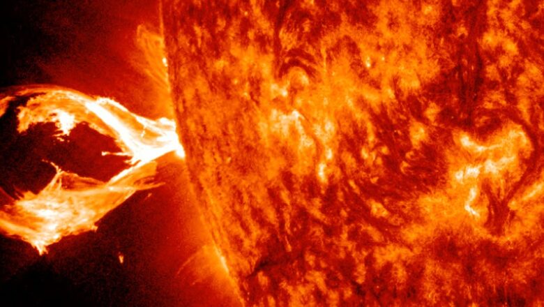
Scientists have issued a warning about a potent solar storm expected to strike Earth this week following powerful eruptions from the Sun. With a 60 percent chance of impact on Tuesday, the storm could cause geomagnetic disruptions and pose risks to power grids and astronauts in space. Despite concerns, no major disruptions have been reported so far. Recent eruptions from the Sun have raised concerns among scientists about the potential impact of an upcoming solar storm on Earth. The National Oceanic and Atmospheric Administration (NOAA) has issued a warning, indicating a 60 percent likelihood of the solar storm hitting Earth on Tuesday, with a lower possibility on Wednesday. The X handle of NASA Sun and Space also confirmed the occurrence of a M6.6-class solar flare on May 13, although ...
Magnitude 6.0 Earthquake Strikes Leyte Province, Philippines

Magnitude 6.0 Earthquake Strikes Leyte Province, Philippines

Breaking News, Disasters
The central Philippines was rattled by a powerful offshore earthquake, registering a preliminary magnitude of 6.0, according to the Philippine Institute of Volcanology and Seismology (PHIVOLCS). The quake struck Leyte province at 6:16 p.m. local time, sending tremors across the region and prompting concerns about potential aftershocks and damage. The epicenter of the quake was located approximately 32 kilometers southeast of Dulag, a coastal town in Leyte province, at a depth of 8 kilometers beneath the Earth's surface. Residents in the affected areas reported feeling strong shaking, raising fears of structural damage and disruptions. Given the tectonic nature of the quake, PHIVOLCS warned of the likelihood of aftershocks, urging residents to remain vigilant and take necessary precau...
Ruang Volcano Eruptions Prompt Evacuation of Hundreds in North Sulawesi

Ruang Volcano Eruptions Prompt Evacuation of Hundreds in North Sulawesi

Breaking News, Disasters
Amidst multiple eruptions of Indonesia's Ruang volcano, located in North Sulawesi province, at least 800 individuals have been evacuated from the area, revealed the country's volcanology agency on Wednesday. Situated on Ruang Island approximately 100 km (62 miles) from the provincial capital Manado, the volcano has unleashed its fury in several eruptions since Tuesday, prompting authorities to escalate the alert level to the second highest. The eruptions, triggered by recent earthquakes on the island, have led to the emission of hazardous and "explosive hot clouds" reaching heights of up to 1.8 km (1.1 miles) into the sky, as confirmed by Heruningtyas Desi Purnamasari, an official at Indonesia's Center for Volcanology and Geological Hazard Mitigation (PVMBG). "To ensure safety, we...